Saturday the nineteenth of August, 2006, I awoke at a rest area west of San Mateo, California, at around 5:30 or 6 in the a.m. It was far too early to be up, but I didn’t have much choice: that was when I awoke, and I tell you, there was no going back. So, I went and brushed my teeth, came back to my truck, and got on the traffic-less freeway heading into San Francisco. It was very foggy.
I rolled into San Francisco sometime later (approximately 6:30 in the a.m. as I’ve come to realize from looking at the photograph information), and was greeted by much fog. I did see a road sign that made it seem as though the road it was designating shared a name with my nephew, so that was neat.
I got into San Francisco proper, and didn’t really know what to do with myself. After all, I was naught but an ignorant tourist in a giant city at 6:30 on a Saturday morning toward the end of summer. So, I did what I had little choice but to do (and manage to keep the major themes of my epic journey intact): I drove around. Boy howdy, did I ever drive around that city. Here’s a picture of... well, I don’t remember at all what road it is, but you can tell it’s quite hilly, and you can also tell that my truck was there, so it’s a picture somehow involving my truck on a hilly road in San Francisco.

I did a lot of driving around. I figured there were some famous streets that I drove around on, but being as I didn’t know for what reasons those roads I was driving may or may not have been famous, I didn’t really care. What I thought was neat, was the city itself. It’s a place that I’d definitely like to go to for a while some day later on, and further explore it. The same goes for Chicago, but I didn’t just meander through the Chicago streets the way I meandered the streets of San Francisco. I believe I drove on Mission, I know I drove Lombard, there was a tunnel in the middle of the city that I went through, and I saw several neat churches/cathedrals. Here’s one, and pay close attention to the double decker bus in the(relative) foreground:

And then... I drove around some more! While stopped (wisely) at a stoplight, I happened to notice a somewhat pyramid shaped building off in the distance. Now, I’m really not sure what the building is all about, but I’m fairly certain that I saw it in a video game some years back. If anyone out there has played ‘Driver: You Are The Wheel Man,’ and can verify for me, that would be awesome. Anyway, I thought that the event in question was extremely worthy of digital documentation, so here is the photograph I took of the pyramidal building in San Francisco:

Then I made my way through the city, up and down its many hills (though probably not all of them), imagined what a nightmare parking must be in that city on a high traffic day, then imagine what driving a stick-shift car must be like on those hills on a high traffic day must be like, then drove to the Promenade. You know, I’m not actually sure whether or not ‘Promenade’ ought to be capitalized, but when I say it aloud, I think of it as being capitalized. Maybe I have some sort of reverence for the word. Anyhow, it took me a while to figure out the roads to get there because I was fairly certain that if I didn’t make the turn in time I would be taken straight over the Golden Gate Bridge and into whatever area was north of San Francisco, wouldn’t be able to make a U-turn on the bridge (as I later found out), and would refuse to pay the toll to come back to San Francisco from the north. So, it was vitally important that I take the time to find out just what roads exactly that I needed to take in order to arrive safely at the Promenade. I got there alright, and even though it was very much foggy, I thought the place was awesome. Although, and this will mean more later, I liked it better before I went up to the bridge. Here’s the bridge from the Promenade:

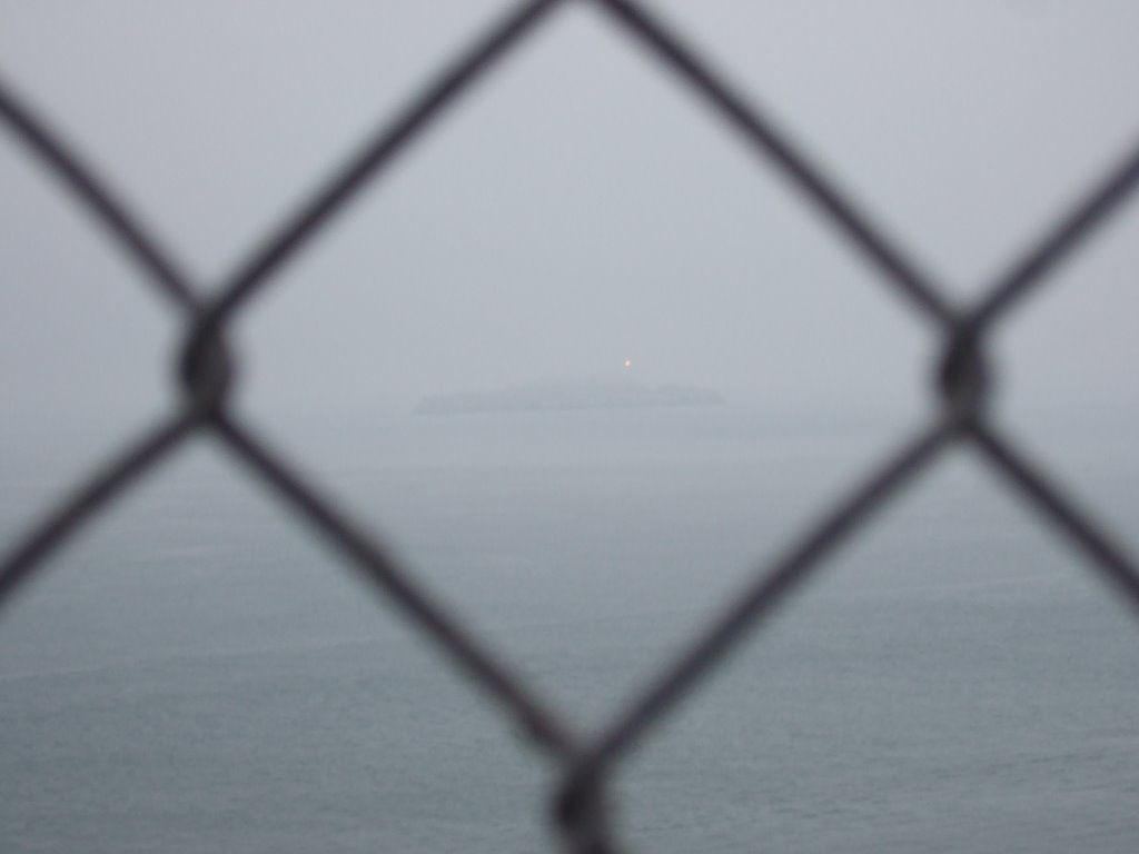
After I took many, many pictures of the bridge and the Rock, I decided to go for a walk up the hill. I ambled about for some time, looked at the old gun emplacements (they looked like little dugout homes), went through a low-ceilinged tunnel, and found myself looking at the Golden Gate Bridge (well, most of it... the top third or so was still rendered invisible by the fog) from approximately its own altitude. It’s a pretty amazing structure. I also took some pictures from various points of the nineteenth century fort below the bridge; I believe it’s called Fort Point, though I’m not absolutely certain of that... now I am, however. Here’s a picture of Alcatraz through a fence on the bridge deck:
Also from the bridge deck, this sign was posted, and I thought it quite an interesting warning. No throwing missiles! That would be a misdemeanor! Also, you’re on television!

Here’s a picture of the bridge disappearing into the sky. Also, the posting about U turns... it just seems to me like something as significant as that should go very much without saying:

The size of the Golden Gate Bridge is really hard to show in a really significant way, so I’ll try a different way than simply showing a picture. There are many rivets in the next picture, and they are at least an inch wide, but probably more like 2”. I hope that helps!

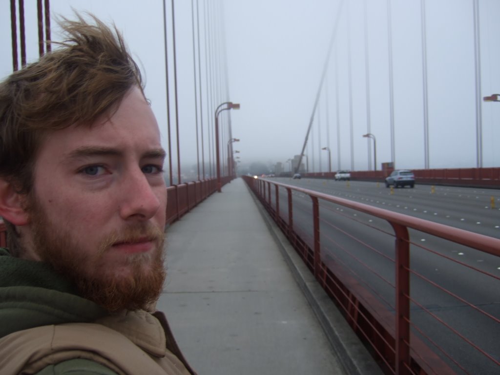
The wind was blowing fairly significantly, and it had been a fairly cold morning, so I was as bundled up as I had been to any point previous in my trip. Mostly it’s the vest, though. Anyway, I really feel like this is my ‘correspondent picture.’ It’s like I’m some kind of journalist, reporting from a wind-torn third world city, whose famousest bridge is dangerously fogged in.
Here it is from the other side. Actually, it’s the other side of the other side. I crossed the bridge the long way, then I crossed it the short way, climbed a bit of a hill, and took a picture. This is that picture:
 This is what the fogged over bridge looked like after I climbed up and over that hill in the above picture (actually, that sounds a bit deceptive, I actually drove up a road before doing any of the picturing).

Then I got back on the 1/101 and drove through a tunnel. Then I wound through some hilly areas and saw this sight:

And I thought to myself, there must be a view from that hill, because that’s the only thing I can think of that will put that many houses into such a dense proximity. If you really think about it, I think you’ll probably agree.
I drove ‘round on the pacific coast highway for a while after that before making any further stops, then I got stuck on some twisty roads behind a motorhome that was significantly longer than a sign had stated previously was alright to proceed. They were going slow to begin with, but on top of that, they were having significant troubles with the switchbacks. I saw that there was to be a scenic view at the next left and, since I knew I’d be able to catch up with the motorhome pretty quickly anyway, I decided to see what the scenic view had to offer. It was a really neat sort of highland lookout. There was a very narrow path that went out over the top of a ridge that jutted out away from the mainland before suddenly dropping into the sea. I desperately wanted to walk out on the path, but it was significantly blocked for no apparent reason, so I contented myself with exploring the wind bunkers.

The path I wanted to take is pretty obvious in the picture, but the wind bunker is a little more subtle. The path is in the center of the photograph. Basically. Well, it’s really the focal point, more than the center. Anyway, the bunker is right at the bottom. You can probably see a panel of expanded metal that’s been set in concrete. That is actually the skylight, I guess, of the bunker. There were probably four of five of them total, and they all looked pretty much the same. They were roughly cube shaped, with the water side wall only being about four feet tall but even with the ground. The roof of these odd contraptions came over the top but ended roughly four feet short of the front (short) wall, and, as you can imagine, those little four foot by four foot corners from the side walls were absent as well. In two of the bunkers, there was a small post set into the floor. They were close to the front wall, and probably only about three feet tall. There was one such post in the bunker I chose to climb down into. I used it as a step to get back out, because there were no stairs or anything.
Back onto the roads of death! Here is an example of what I’m talking about:
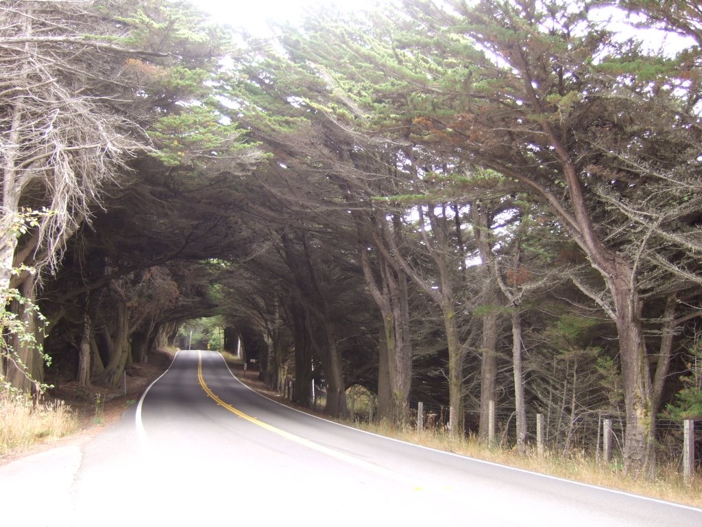
 Along with the many dangers, toils, and snares that the road had to offer, there were also many rewards, and other things that would sound good with the word ‘rewards’ in a sentence such as this. There were several sections of road that I passed through (over) that were tree lined and had the effect of being a tunnel. Like this:
Speaking of tunnels, here’s another, slightly smaller one:

Wait a second, that’s not a tunnel at all! Why, that’s the drive-through redwood tree near Legget, CA! I got there and there was no one behind me, I looked at that tree and thought, “Ha, that’s for cars of a different era, there’s no way my truck would fit through that! I bet it’s just for looking at now.” That may not be verbatim (as much as thoughts can be translated into words), but it’s pretty close. Then a motorcyclist (pictured) rode through it, and that made sense. The fence doesn’t block the tree off, or anything, and it’s obvious that a motorcycle would fit, so why not? And then came the others.

First there was a regular midsized car. I thought that it would fit ok. Then came the minivan/SUV cross-breed thing. I had serious doubts about that one, especially when looking at the little head coming out the roof. It occurred to me that the car had become so condensed in traveling through the tree, that the bodies were emerging from the car under such pressure, that they were forcing the metal apart for room to expand. As it turned out, everyone was ok, and the car had a sunroof. Plus, they pulled their weird foldable mirrors in to avoid breaking them off on the tree. Then, the one that really got me was a full-sized Ford pickup. They pulled the mirrors in on that truck, and crept through as slowly as was reasonable. I was told that there was less than an inch of clearance on either side. That made me think beyond all doubt that I could have driven my truck through the tree. Then I figured that I would have had to pull my mirrors in, and mine are the older, much more difficult to get just right, style. Plus, and this is really the big one, I certainly would not have been able to get out and get a picture of my truck in a tree. I think the thing that amazes me most about that whole place is that the tree is still alive. And it’s not just alive in a ‘well, it’s got some green on it, way up at the top,’ kind of way, it looks like a giant tree still. I don’t imagine that this hole cut in the base of the tree is a recent occurrence, either. I get the feeling that the tree has not been whole in quite a long time, and has just learned to cope with that fact, and has adapted in as good a way as it can. It appears to be thriving.
Legget is also where California 1 ended by merging with U.S. 101 for the last time. Once I merged with 101, I traveled it for only a little while before seeing an exit for a road called ‘Avenue of the Giants.’ Plus, the sign made it sound like it was just a loop, and would reconnect with 101 after a short while. I took it, and because I did, I passed through Hobbiton. At first, I thought it was some kind of coincidence, but then I saw the sign.

They had named their town after a place in “Lord of the Rings.” I’m still not sure if I think that’s pretty great, or just really weird.

And it seems to imply that I would have to turn to take the Avenue of the Giants, but I offer this alternate suggestion (so many colons “:” in (technically) one sentence, what have I done?): I think the sign is saying that you have to take that right turn to stay on the Avenue of the Giants. Also, the sign says that the freeway (which can only be the 101) is a quarter mile to the left, and I know I was either on the 101 or the Ave. of the Giants. My conclusion is that I was still on the Avenue of the Giants, and that Hobbiton is, too.
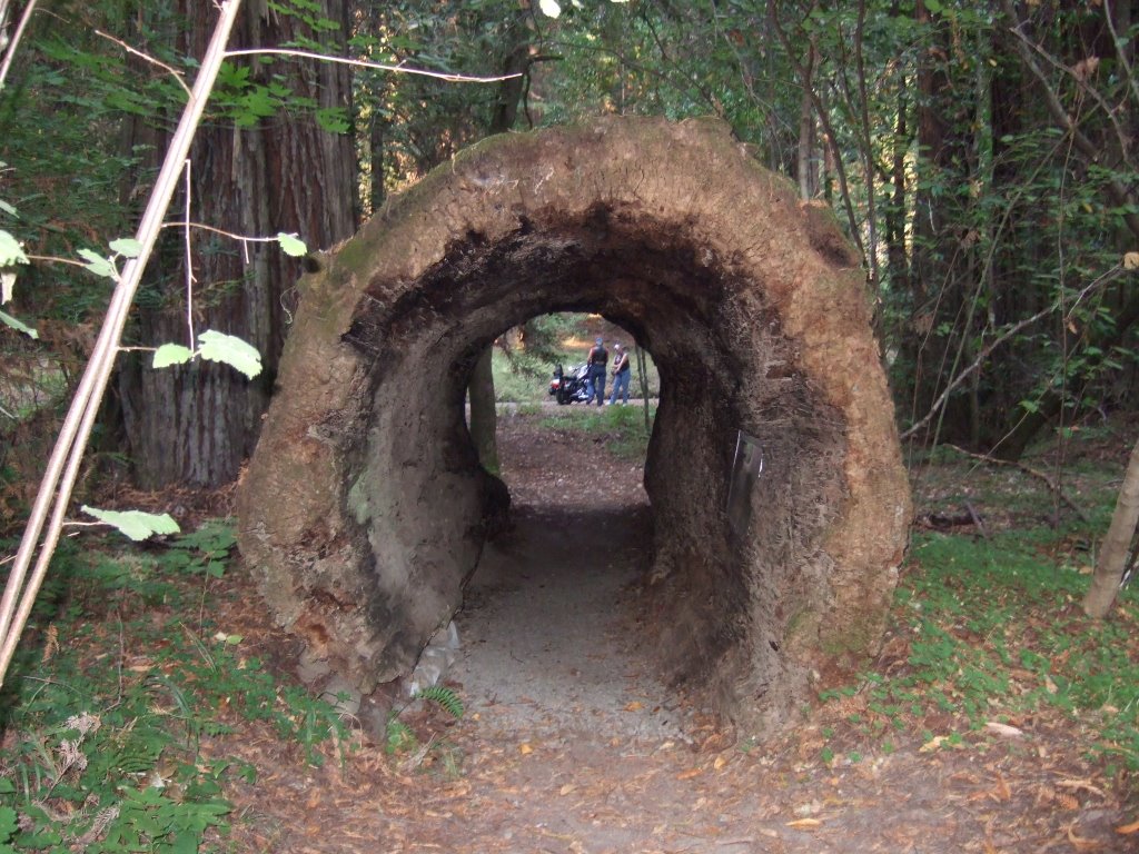
Here’s a fallen log that’s been hollowed out enough to fit a couple of bikers.
I stopped and talked to them for a while, and they told me that a few years back they drove a crane from Atlanta to L.A. on Route 66. And I’m certain that at least one detail in their story is false. Or, maybe they just didn’t fill in all the blanks.
Here’s a picture of me at the hollow log. I like this picture because it looks like I’ve ‘photoshopped’ myself into it.

I drove on through the foresty areas of
After the movie, I went back to the 101, got some gas, and headed into the starless night, on the lightless road, engulfed by smothering fog! It was one of those sections of road that, when you’re on it by yourself you really don’t want to go very fast because at any moment it could turn sharply, and leave you flying off a cliff into the Pacific. Now, if you’re lucky enough to be behind someone crazier than yourself, then it’s all good, because they’re willing to take those turns, and you (or at least I) can better gauge how fast I want to be driving on these roads that are difficult to gauge. There were a couple of instances when I fortunate enough to be behind such crazy people, but they proved far too crazy for my tastes. They were going much faster on these dangerous roads than even I was comfortable following them. Everything turned out alright, though, because I arrived at my intended (only) rest area to the north of
No comments:
Post a Comment