I awoke in comfort, showered, contintentally breakfasted, and then internetted. Upon realizing that the internet I was using didn’t seem to be functioning in a wholly appropriate way, I packed up and left that Grants motel. I was heading for the ice cave.
I knew that the ice cave was south of the city of Grants, and I knew which direction was south, so I headed that way. Unfortunately, the road came to a T just south of the interstate. I didn’t know quite what to do. I knew that there was a clearly marked road on my map that said where to go, yet there I was, with clearly no where to go.
I had seen a sign for a visitor center not long before that, so I decided to head back in that general direction. When I got to the visitor center, I was a little surprised to be the only person there, and wondered if the establishment wasn’t closed. The parking lot was completely empty. I wandered on in, asked the man at the desk my question, and he told me that I needed to go one exit further west and then turn south. He gave me a handy map (which I didn’t actually use), looked a little dejected as I thanked him, and went back to reading his book.
Getting back under way, I headed for the interstate, went west, left the interstate, went south, found what I was looking for, stopped, went inside, acquired the necessary information, asked about discounts, got one, paid the money, and headed out to see a volcano. I think I might know what you’re thinking at this point: ‘he was looking for an ice cave, yet he went to see a volcano?’ The short answer is yes. The long answer is considerably longer, and begins now: Apparently the site is called the land of fire and ice, and the ice cave most likely wouldn’t be there if not for the massive volcano eruption that happened in a land before time.
I don’t remember the details of the pairing, but the lava flow is what carved out the cave, and somehow it stays cool enough down there (31 degrees Fahrenheit) to freeze the water into ice (in the cave).
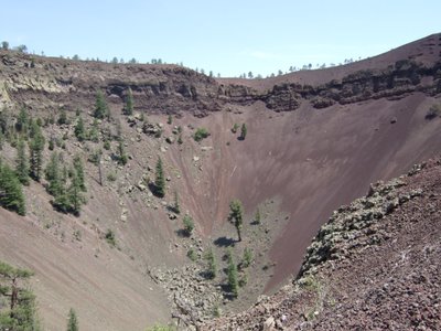
So I walked up to the volcano. I couldn’t get a super good angle, but here’s probably the best picture I could get of it:
An interesting tid bit about the environment in that area is that the lava from the volcano left the ground rather mineral-rich. As such, the trees there grew with a higher-than-normal iron content, and because of this were much more likely to be struck by lightning. And it was fairly obvious that many of them had been. There were also a lot of twisted trees there. It was neat.
On my way back down, I had to pass by the office again, and I noticed a hummingbird feeder. It must have been lunch time for the little birds, too, because there must have been a baker’s dozen of them in the general vicinity.
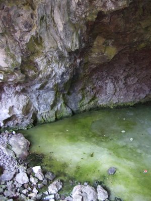
I took some pictures of the little hummers and continued on my way. It wasn’t too far before I found the steep set of stairs and began the descent. With each passing step it became noticeably cooler. Suddenly, I was at the bottom of the stairs on a platform, there were rocks there with different colored moss (there were kind of on a sort of crest at the entrance to the cave where sunlight could hit occasionally). It wasn’t the sort of ice cave I was thinking of, but that’s only because the kind of ice cave I was thinking of is the kind I’ve been to previously. Which is to say, basically a hill of snow-ice with holes forming in the base. This was not that. This was a cave with frozen water in the bottom. Green frozen water. There were some ice formations hanging from the ceiling of the cave as well, but they didn’t turn out so great. Well, see for yourself:
I took my pictures and headed back, I checked in at the office to tell them that I was safe, unharmed, and leaving. Then, I left.
I went back the way I’d come, north toward the western exit at Grants, and found the highway I’d been looking for the night before. Somewhere in there was a sign that didn’t know what it was informing people of, because it wasn’t right. I’d found my highway though, and I drove it.
The continental divide needed to be crossed one more time, and I did so. But, before I did, I found this sign, and took a picture of it because I thought it rather ironic. Ironic because it speaks of how rain which falls at that point will either drain into the Pacific or the Gulf of Mexico, but clearly there is a puddle there which is about to go nowhere.

At some point shortly after that I drove further on old Route 66 and found another road closed sign, and was made to feel sad.

Shortly before I entered Gallup, NM, I noticed the landscape begin to change a little, and decided to take a picture. I just thought it was neat, but it turned out that this was nothing compared to what I would see later in the day.

But before the later in the day of which I just made mention was to happen, I had to pass through Gallup, wherein I would see El Rancho Motel, ‘Home of the Movie Stars.’ It’s apparently a pretty big historical landmark on Route 66.

I thought it was neat, but didn’t stay for very long. I basically stopped in the parking lot, took my shots, and then headed out. Arizona or bust.
Arizona crept up on me. I was on a road that, and this is the only time I’ve ever seen this, emptied into a rest area. From the rest area, you could either go back out on the road you came in on, or you could go out on the freeway, those were your two options. As I had passed into the rest area, I’d seen an Arizona state line sign. But to get back on the freeway, I needed to pass back into New Mexico and then back into Arizona.
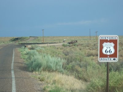
My guidebook said that for a long stretch in Arizona, Route 66 was a series of dead-ends, so it was just best to stay on the free way for a while. I did so, and made an exit into the Petrified Forest National Park. There I got gas, thriftily put my Yellowstone admission price toward a year long national park pass, and saw some awesome sights.
I got into the park at about 5 o’clock, and the park had a posted sign that it would close at 7. I didn’t really know what that meant. Do they stop allowing people in at 7? Do they herd us out cattle-drive style? So many questions...
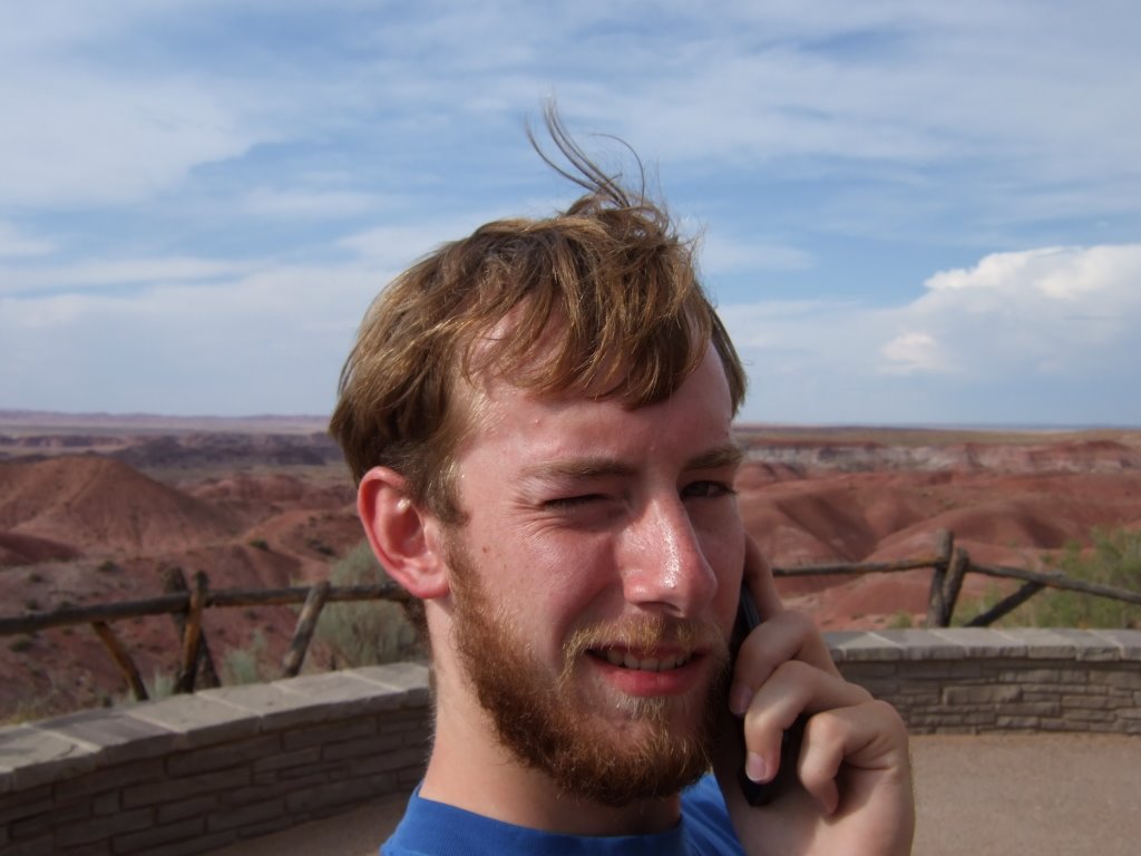
I didn’t know what was going to happen, but I wasn’t going to let that stop me from having a good time and seeing some great sights. Nor from calling my dad, from the Painted Desert.

Now I’m going to show you a lot of stuff, without saying very much, because I saw a lot of great stuff without much happening in between sights. Here we go:
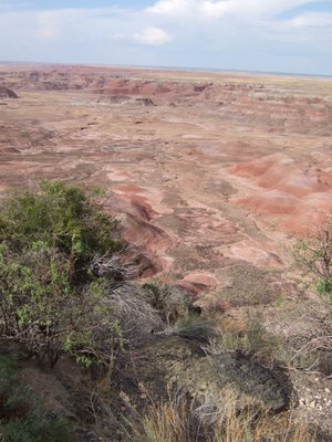
This is a picture of the fantastic painted desert:
As I was leaving that lookout, I stopped because I thought this looked like a neat scene, what with the road going off into the gray not-so-distant distance.

Driving along, I thought to myself, ‘I wonder why there’s a car in the middle of the national park?’
It turns out that old Route 66 runs through the park, or used to, and they set up a little memorial to that section of road. Here’s a different view of the car:

Then it was on to the petroglyphs. These ones are right near a former village that is being unearthed:

Speaking of villages that are being unearthed:

I thought this next photo was great, if for no other reason that its obviousness (the fact that the sign stands in front of a near-sheer cliff):

Then it was time for me to take a bit of a hike. I wanted to see what these painted hills were really made of. So, right before I began my latest descent in earnest, I took this (and other) photo(s):

And, to those out there who are curious, here is what these hills look like up close and personal:

This photograph isn’t of anything in particular, I just rather like it, and feel like sharing it with the world. If the world chooses to view it, so much the better.

Here is what’s called the ‘Agate Bridge.’ It is a fallen tree that was petrified, and the soft dirt beneath has been washed away. A sign I saw said that over time this trend would continue to the point that the bridge would have nothing left to rest upon unless braced. So, it was determined that they should pour concrete supports for it, and did.

And here, for no other reason than I thought it looked neat, is another fallen petrified log, or chunks of one. I think of it as petrified fire wood.

I wasn’t as impressed by the petrified forest as I thought I’d be. Maybe that’s because it was getting dark, maybe it’s because I’d just seen the painted desert (which my guide book told me to skip in favor of the petrified forest) or maybe it’s because I’d just seen all of these amazing things and there was a lightning storm in the distance. In any event, I think I liked the painted desert more. When I hear ‘petrified forest’ I think ‘still-standing trees.’ There were stumps and chunks, but no trees were standing. Oh well, here you go, but don’t let my assessment color yours, I still thought it was neat (and well worth seeing):

Lastly, they call that area the ‘Rainbow Forest,’ I believe, and this is the one photograph of the many I took that best represents the reason for that name being chosen:
The tree-rocks are quite colorful in the right light (which I unfortunately only got a vague idea of).
There were other things to see in the park, but by then it was well after 7, and nearly completely dark. I was a little bit sad that I wouldn’t get to see the other couple of stops, but more than happy that I’d seen all that I had.
I got back out on the park road, and followed it until I was out of the park, then I took a highway north and westerly to Holbrook, where I stopped in during the lightning storm at one Super 8. I was issued a ground floor room, unpacked my stuff, tried the television and found no such comedy central, the best thing I could find to watch was the SciFi channel, which was showing a Dark Angel marathon, and a couple episodes of their new show Eureka (which I found rather curious). Then, after my stupidly long and enjoyable day, I fell asleep.
 An interesting tid bit about the environment in that area is that the lava from the volcano left the ground rather mineral-rich. As such, the trees there grew with a higher-than-normal iron content, and because of this were much more likely to be struck by lightning. And it was fairly obvious that many of them had been. There were also a lot of twisted trees there. It was neat.
On my way back down, I had to pass by the office again, and I noticed a hummingbird feeder. It must have been lunch time for the little birds, too, because there must have been a baker’s dozen of them in the general vicinity.
I took some pictures of the little hummers and continued on my way. It wasn’t too far before I found the steep set of stairs and began the descent. With each passing step it became noticeably cooler. Suddenly, I was at the bottom of the stairs on a platform, there were rocks there with different colored moss (there were kind of on a sort of crest at the entrance to the cave where sunlight could hit occasionally). It wasn’t the sort of ice cave I was thinking of, but that’s only because the kind of ice cave I was thinking of is the kind I’ve been to previously. Which is to say, basically a hill of snow-ice with holes forming in the base. This was not that. This was a cave with frozen water in the bottom. Green frozen water. There were some ice formations hanging from the ceiling of the cave as well, but they didn’t turn out so great. Well, see for yourself:
An interesting tid bit about the environment in that area is that the lava from the volcano left the ground rather mineral-rich. As such, the trees there grew with a higher-than-normal iron content, and because of this were much more likely to be struck by lightning. And it was fairly obvious that many of them had been. There were also a lot of twisted trees there. It was neat.
On my way back down, I had to pass by the office again, and I noticed a hummingbird feeder. It must have been lunch time for the little birds, too, because there must have been a baker’s dozen of them in the general vicinity.
I took some pictures of the little hummers and continued on my way. It wasn’t too far before I found the steep set of stairs and began the descent. With each passing step it became noticeably cooler. Suddenly, I was at the bottom of the stairs on a platform, there were rocks there with different colored moss (there were kind of on a sort of crest at the entrance to the cave where sunlight could hit occasionally). It wasn’t the sort of ice cave I was thinking of, but that’s only because the kind of ice cave I was thinking of is the kind I’ve been to previously. Which is to say, basically a hill of snow-ice with holes forming in the base. This was not that. This was a cave with frozen water in the bottom. Green frozen water. There were some ice formations hanging from the ceiling of the cave as well, but they didn’t turn out so great. Well, see for yourself:
 I took my pictures and headed back, I checked in at the office to tell them that I was safe, unharmed, and leaving. Then, I left.
I went back the way I’d come, north toward the western exit at Grants, and found the highway I’d been looking for the night before. Somewhere in there was a sign that didn’t know what it was informing people of, because it wasn’t right. I’d found my highway though, and I drove it.
The continental divide needed to be crossed one more time, and I did so. But, before I did, I found this sign, and took a picture of it because I thought it rather ironic. Ironic because it speaks of how rain which falls at that point will either drain into the Pacific or the Gulf of Mexico, but clearly there is a puddle there which is about to go nowhere.
I took my pictures and headed back, I checked in at the office to tell them that I was safe, unharmed, and leaving. Then, I left.
I went back the way I’d come, north toward the western exit at Grants, and found the highway I’d been looking for the night before. Somewhere in there was a sign that didn’t know what it was informing people of, because it wasn’t right. I’d found my highway though, and I drove it.
The continental divide needed to be crossed one more time, and I did so. But, before I did, I found this sign, and took a picture of it because I thought it rather ironic. Ironic because it speaks of how rain which falls at that point will either drain into the Pacific or the Gulf of Mexico, but clearly there is a puddle there which is about to go nowhere.
 At some point shortly after that I drove further on old Route 66 and found another road closed sign, and was made to feel sad.
 Shortly before I entered Gallup, NM, I noticed the landscape begin to change a little, and decided to take a picture. I just thought it was neat, but it turned out that this was nothing compared to what I would see later in the day.
 But before the later in the day of which I just made mention was to happen, I had to pass through Gallup, wherein I would see El Rancho Motel, ‘Home of the Movie Stars.’ It’s apparently a pretty big historical landmark on Route 66.
 I thought it was neat, but didn’t stay for very long. I basically stopped in the parking lot, took my shots, and then headed out. Arizona or bust.
Arizona crept up on me. I was on a road that, and this is the only time I’ve ever seen this, emptied into a rest area. From the rest area, you could either go back out on the road you came in on, or you could go out on the freeway, those were your two options. As I had passed into the rest area, I’d seen an Arizona state line sign. But to get back on the freeway, I needed to pass back into New Mexico and then back into Arizona.
My guidebook said that for a long stretch in Arizona, Route 66 was a series of dead-ends, so it was just best to stay on the free way for a while. I did so, and made an exit into the Petrified Forest National Park. There I got gas, thriftily put my Yellowstone admission price toward a year long national park pass, and saw some awesome sights.
I got into the park at about 5 o’clock, and the park had a posted sign that it would close at 7. I didn’t really know what that meant. Do they stop allowing people in at 7? Do they herd us out cattle-drive style? So many questions...
I didn’t know what was going to happen, but I wasn’t going to let that stop me from having a good time and seeing some great sights. Nor from calling my dad, from the Painted Desert.
I thought it was neat, but didn’t stay for very long. I basically stopped in the parking lot, took my shots, and then headed out. Arizona or bust.
Arizona crept up on me. I was on a road that, and this is the only time I’ve ever seen this, emptied into a rest area. From the rest area, you could either go back out on the road you came in on, or you could go out on the freeway, those were your two options. As I had passed into the rest area, I’d seen an Arizona state line sign. But to get back on the freeway, I needed to pass back into New Mexico and then back into Arizona.
My guidebook said that for a long stretch in Arizona, Route 66 was a series of dead-ends, so it was just best to stay on the free way for a while. I did so, and made an exit into the Petrified Forest National Park. There I got gas, thriftily put my Yellowstone admission price toward a year long national park pass, and saw some awesome sights.
I got into the park at about 5 o’clock, and the park had a posted sign that it would close at 7. I didn’t really know what that meant. Do they stop allowing people in at 7? Do they herd us out cattle-drive style? So many questions...
I didn’t know what was going to happen, but I wasn’t going to let that stop me from having a good time and seeing some great sights. Nor from calling my dad, from the Painted Desert.
 Now I’m going to show you a lot of stuff, without saying very much, because I saw a lot of great stuff without much happening in between sights. Here we go:
This is a picture of the fantastic painted desert:
Now I’m going to show you a lot of stuff, without saying very much, because I saw a lot of great stuff without much happening in between sights. Here we go:
This is a picture of the fantastic painted desert:
 As I was leaving that lookout, I stopped because I thought this looked like a neat scene, what with the road going off into the gray not-so-distant distance.
 Driving along, I thought to myself, ‘I wonder why there’s a car in the middle of the national park?’
 It turns out that old Route 66 runs through the park, or used to, and they set up a little memorial to that section of road. Here’s a different view of the car:
 Then it was on to the petroglyphs. These ones are right near a former village that is being unearthed:
 Speaking of villages that are being unearthed:
 I thought this next photo was great, if for no other reason that its obviousness (the fact that the sign stands in front of a near-sheer cliff):
 Then it was time for me to take a bit of a hike. I wanted to see what these painted hills were really made of. So, right before I began my latest descent in earnest, I took this (and other) photo(s):
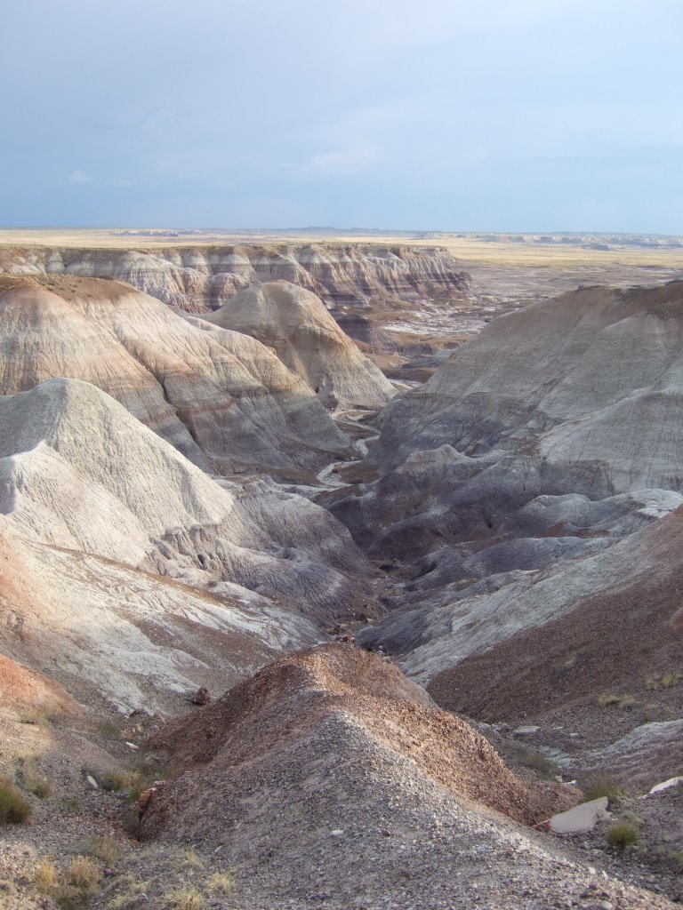 And, to those out there who are curious, here is what these hills look like up close and personal:
 This photograph isn’t of anything in particular, I just rather like it, and feel like sharing it with the world. If the world chooses to view it, so much the better.
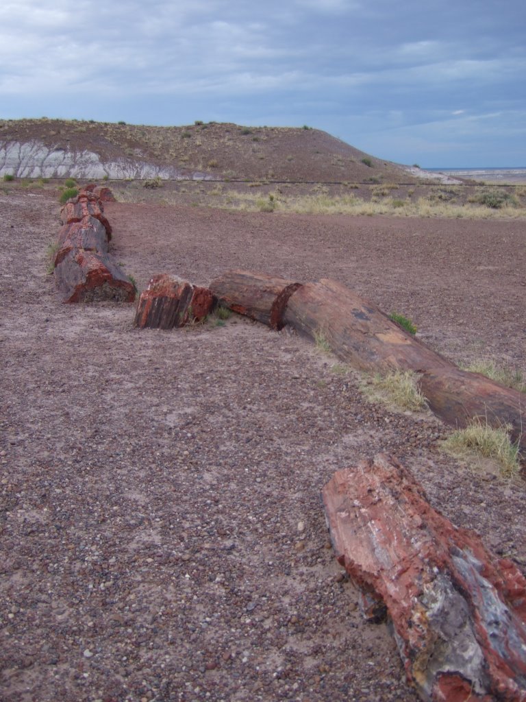
 Here is what’s called the ‘Agate Bridge.’ It is a fallen tree that was petrified, and the soft dirt beneath has been washed away. A sign I saw said that over time this trend would continue to the point that the bridge would have nothing left to rest upon unless braced. So, it was determined that they should pour concrete supports for it, and did.
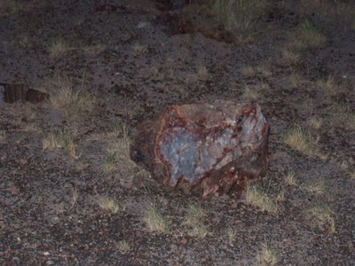
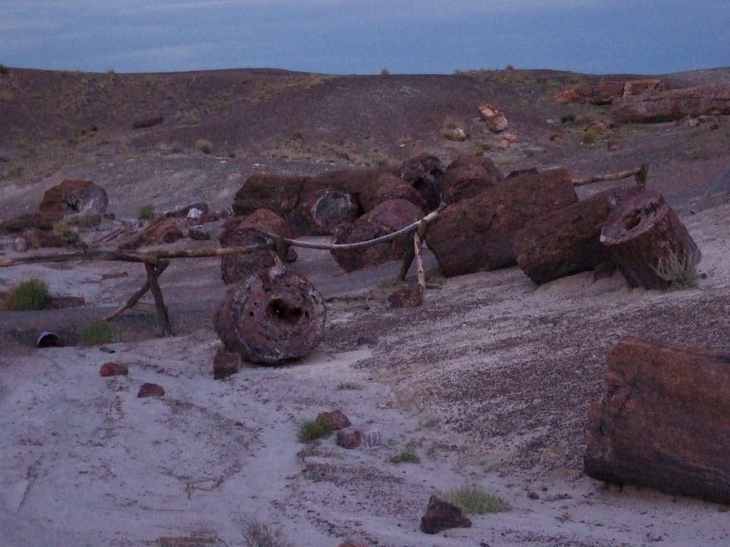
 And here, for no other reason than I thought it looked neat, is another fallen petrified log, or chunks of one. I think of it as petrified fire wood.
 I wasn’t as impressed by the petrified forest as I thought I’d be. Maybe that’s because it was getting dark, maybe it’s because I’d just seen the painted desert (which my guide book told me to skip in favor of the petrified forest) or maybe it’s because I’d just seen all of these amazing things and there was a lightning storm in the distance. In any event, I think I liked the painted desert more. When I hear ‘petrified forest’ I think ‘still-standing trees.’ There were stumps and chunks, but no trees were standing. Oh well, here you go, but don’t let my assessment color yours, I still thought it was neat (and well worth seeing):
 Lastly, they call that area the ‘Rainbow Forest,’ I believe, and this is the one photograph of the many I took that best represents the reason for that name being chosen:
 The tree-rocks are quite colorful in the right light (which I unfortunately only got a vague idea of).
There were other things to see in the park, but by then it was well after 7, and nearly completely dark. I was a little bit sad that I wouldn’t get to see the other couple of stops, but more than happy that I’d seen all that I had.
I got back out on the park road, and followed it until I was out of the park, then I took a highway north and westerly to Holbrook, where I stopped in during the lightning storm at one Super 8. I was issued a ground floor room, unpacked my stuff, tried the television and found no such comedy central, the best thing I could find to watch was the SciFi channel, which was showing a Dark Angel marathon, and a couple episodes of their new show Eureka (which I found rather curious). Then, after my stupidly long and enjoyable day, I fell asleep.
The tree-rocks are quite colorful in the right light (which I unfortunately only got a vague idea of).
There were other things to see in the park, but by then it was well after 7, and nearly completely dark. I was a little bit sad that I wouldn’t get to see the other couple of stops, but more than happy that I’d seen all that I had.
I got back out on the park road, and followed it until I was out of the park, then I took a highway north and westerly to Holbrook, where I stopped in during the lightning storm at one Super 8. I was issued a ground floor room, unpacked my stuff, tried the television and found no such comedy central, the best thing I could find to watch was the SciFi channel, which was showing a Dark Angel marathon, and a couple episodes of their new show Eureka (which I found rather curious). Then, after my stupidly long and enjoyable day, I fell asleep.
No comments:
Post a Comment