I got kind of a late start again today. Since leaving home that seems to be the trend. Late start, early finish. It’s not for lack of adventurous spirit, however, I have good intentions for what I plan to do with the evenings that I stop early (in fact, I’m writing this from tomorrow, but don’t tell anyone!).
The thing of it is, I stop driving early so that I can get some writing done, but then get tired and don’t write. Or I worry about the computer’s battery going dead or some other little thing. But I end up just going to sleep, and having to make up for it in the morning—which now that I’m in Montana isn’t particularly helpful, because I’m an hour behind this ‘Mountain Time.’ I don’t know whether it’s something I should try and get used to or not. My cell phone doesn’t know that it’s Mountain Time here—which is unfortunate, because most of the place I’ve been to so far the thing has only amounted to a glorified clock.
Alright, enough of my inner mental meanderings, here’s what happened to me today, which is to say yesterday.
I woke up, took a long time figuring out what I needed to do in terms of rearranging my truck, and in terms of what I wanted to eat. Once I’d gotten those things figured out, I organized my photos, and began typing accordingly. Then the interior of my truck got boring, so decided to retire to the outside. There was a little picnic table up a hill from where I was parked. I sat there, and all was well until the bugs came. You may or may not remember the incident with the bee.
Oh well, mine is not to recount the adventures in typing that I’ve had so far, nay, but to recount the adventures in... well, I’m not sure exactly, but to tell you all what I’ve been up to, anyway.
I gathered all my stuff together, and decided (after I brushed my teeth and filled up my water bottles) that it was time to go. And go I did. Up highway 12, which kept having ‘Lewis and Clark Trail’ signs posted, and I kept wanting to take a picture of one, but kept getting discouraged because the road was so narrow and I couldn’t find a place to stop and take a picture of one. Finally, I’d decided that the next one I saw, I would stop and take a picture of. Unfortunately I didn’t see another single sign of that nature on highway 12, but one surprised me on highway 93. So much so that I didn’t have time to take a picture of it. However, I am resolved that, should I see another one, I will take a picture of it, even if I have to turn around and go back to do so.
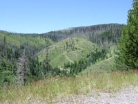
I continued up U.S. 12, on towards Lolo pass, and saw a historic site marker. I stopped out of curiosity, and found some rather interesting information.
Apparently, in various areas of the mountains, land ownership is split between National Forest and a Timber Companies. It’s split up in sort of a checkerboard pattern. For your viewing pleasure, I’ve included a visual representation of this pattern. See if you can guess who owns the white squares, and who owns the black ones (I realize I’ve made more of a ‘chess’ reference here, please forgive me, but I wasn’t sure if saying ‘red squares’ would make much sense...):
I continued on from there, not seeing much of interest for a while.
I stopped at the Lolo pass rest area/visitor center, and knew that I was close to the Idaho/Montana boarder. There were maps of both states on big display boards, but something that confused me severely was the fact that both state maps had Lolo Pass in their own state. I think it was technically in Idaho, because after I went over the summit, I saw the sign that said, “Welcome To Montana.” However, when I looked back, I saw that there was about twenty feet of space between the Montana sign and the Idaho sign. It makes me wonder who that twenty feet of No Man’s Land belongs to. Or maybe the boarder is just twenty feet wide. Wouldn’t that mean that outlaws could have stood on a boarder in the old days, then? In so many movies I’ve seen, they were always headed for the boarder to get out of state, but if they just had to get to a strip of boarder where no one had jurisdiction... it might have made their life on the run a whole lot easier. Or harder, because they wouldn’t have been able to move around very much.
My next stop was Lolo (proper). It was basically an intersection with buildings on all four corners and a stop light where U.S. 12 and U.S. 93 met. Strangely, the cellular reception was fantastic. I thought it odd. I made the call to my parents, caught up, got caught up, and continued on my merry way.
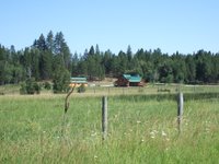
I was headed for a little town called Victor. It’s a place where my uncle used to own a little log cabin—which was actually a pretty massive log house. He threw some big parties there when I was little, and I thought that since I was passing by there, that I would try and find it.
And find it I did, with astounding ease. I made not one single wrong turn. My dad will probably think it’s just a coincidence, but I tell you it wasn’t. Just because I haven’t been there since I was 12 doesn’t mean I’ve forgotten the way!
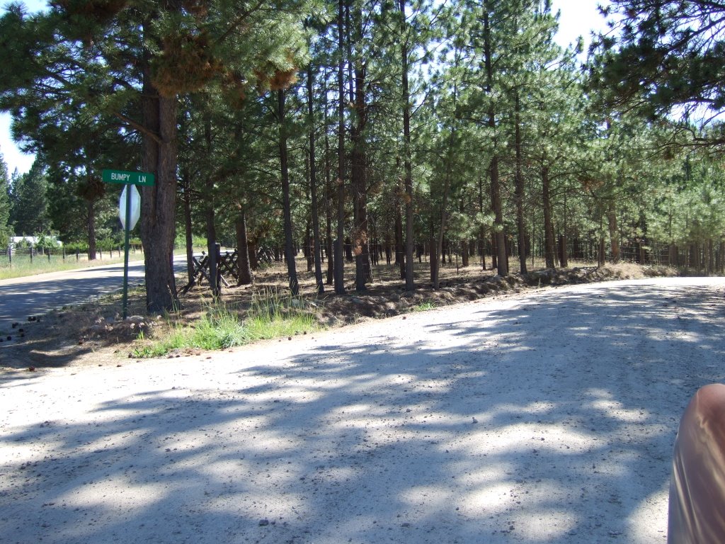
One of the roads to my uncle’s old house is called (very appropriately) Bumpy Lane.

As I neared the house I took more pictures, one of which shows the house and one of the out buildings, which I believe was sort of an all-encompassing garage/barn/apartment. Oh yeah, when they had their parties, there were never enough whole bathrooms. Sure they rented some port-a-potties, but people needed to shower (and that caused some trouble as I recall—I don’t recall specifically what trouble, I just recall trouble).
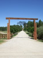
The sign hanging under the ranch gate used to read “W M Ranch,” or something like that, there may have been a “...Victor, MT” after it. It made me sad to see it read something else. And there were way more trees on that drive than I remembered. I went on a covered wagon ride there. O, the memories.
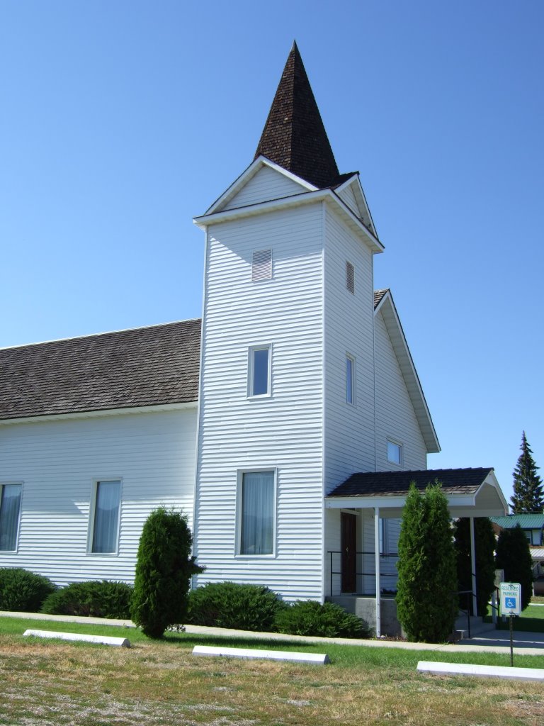
And this, (pictured) for no apparent reason, is Victor’s church.

I got back on the main road south, and soon came to the massive city of Hamilton (which really isn’t very big). I stopped at an Albertson’s, contemplated going to NAPA, actually went to NAPA, but was foiled by Mountain Time. Oh yeah, when I was at Albertson’s, I asked if they knew of anywhere with wireless internet, and one checker said she was new to the area, so I asked at that customer service desk. This woman said that there was an internet café, “over on fourth, but it’s probably closed by now.”
Just then, as she started helping the next customer, I wondered two things: ‘where in blue blazes is fourth?’ and ‘why in blue blazes would an internet café be closed at 7? Even accounting for Mountain Time.’
I drove around, found it, and found that sure enough, it was closed.
So, again, I continued southward.
I saw a sign and thought, “Hey, doesn’t that guy have a brother, or something?”

Southbound on U.S. 93 I saw another historical site marker, I saw a sign, and took a picture. There’s something very eerie about this picture, but I can’t quite say what. The word, ‘doppleganger,’ comes to mind, however.

After that, I found a place to camp. And that was the end of the third day.
Right now, it’s 11:24 in the morning, Mountain Time, and I’m going to put things away and head out.
 I continued on from there, not seeing much of interest for a while.
I stopped at the Lolo pass rest area/visitor center, and knew that I was close to the Idaho/Montana boarder. There were maps of both states on big display boards, but something that confused me severely was the fact that both state maps had Lolo Pass in their own state. I think it was technically in Idaho, because after I went over the summit, I saw the sign that said, “Welcome To Montana.” However, when I looked back, I saw that there was about twenty feet of space between the Montana sign and the Idaho sign. It makes me wonder who that twenty feet of No Man’s Land belongs to. Or maybe the boarder is just twenty feet wide. Wouldn’t that mean that outlaws could have stood on a boarder in the old days, then? In so many movies I’ve seen, they were always headed for the boarder to get out of state, but if they just had to get to a strip of boarder where no one had jurisdiction... it might have made their life on the run a whole lot easier. Or harder, because they wouldn’t have been able to move around very much.
My next stop was Lolo (proper). It was basically an intersection with buildings on all four corners and a stop light where U.S. 12 and U.S. 93 met. Strangely, the cellular reception was fantastic. I thought it odd. I made the call to my parents, caught up, got caught up, and continued on my merry way.
I was headed for a little town called Victor. It’s a place where my uncle used to own a little log cabin—which was actually a pretty massive log house. He threw some big parties there when I was little, and I thought that since I was passing by there, that I would try and find it.
And find it I did, with astounding ease. I made not one single wrong turn. My dad will probably think it’s just a coincidence, but I tell you it wasn’t. Just because I haven’t been there since I was 12 doesn’t mean I’ve forgotten the way!
One of the roads to my uncle’s old house is called (very appropriately) Bumpy Lane.
I continued on from there, not seeing much of interest for a while.
I stopped at the Lolo pass rest area/visitor center, and knew that I was close to the Idaho/Montana boarder. There were maps of both states on big display boards, but something that confused me severely was the fact that both state maps had Lolo Pass in their own state. I think it was technically in Idaho, because after I went over the summit, I saw the sign that said, “Welcome To Montana.” However, when I looked back, I saw that there was about twenty feet of space between the Montana sign and the Idaho sign. It makes me wonder who that twenty feet of No Man’s Land belongs to. Or maybe the boarder is just twenty feet wide. Wouldn’t that mean that outlaws could have stood on a boarder in the old days, then? In so many movies I’ve seen, they were always headed for the boarder to get out of state, but if they just had to get to a strip of boarder where no one had jurisdiction... it might have made their life on the run a whole lot easier. Or harder, because they wouldn’t have been able to move around very much.
My next stop was Lolo (proper). It was basically an intersection with buildings on all four corners and a stop light where U.S. 12 and U.S. 93 met. Strangely, the cellular reception was fantastic. I thought it odd. I made the call to my parents, caught up, got caught up, and continued on my merry way.
I was headed for a little town called Victor. It’s a place where my uncle used to own a little log cabin—which was actually a pretty massive log house. He threw some big parties there when I was little, and I thought that since I was passing by there, that I would try and find it.
And find it I did, with astounding ease. I made not one single wrong turn. My dad will probably think it’s just a coincidence, but I tell you it wasn’t. Just because I haven’t been there since I was 12 doesn’t mean I’ve forgotten the way!
One of the roads to my uncle’s old house is called (very appropriately) Bumpy Lane.
 As I neared the house I took more pictures, one of which shows the house and one of the out buildings, which I believe was sort of an all-encompassing garage/barn/apartment. Oh yeah, when they had their parties, there were never enough whole bathrooms. Sure they rented some port-a-potties, but people needed to shower (and that caused some trouble as I recall—I don’t recall specifically what trouble, I just recall trouble).
 The sign hanging under the ranch gate used to read “W M Ranch,” or something like that, there may have been a “...Victor, MT” after it. It made me sad to see it read something else. And there were way more trees on that drive than I remembered. I went on a covered wagon ride there. O, the memories.
 And this, (pictured) for no apparent reason, is Victor’s church.
 I got back on the main road south, and soon came to the massive city of Hamilton (which really isn’t very big). I stopped at an Albertson’s, contemplated going to NAPA, actually went to NAPA, but was foiled by Mountain Time. Oh yeah, when I was at Albertson’s, I asked if they knew of anywhere with wireless internet, and one checker said she was new to the area, so I asked at that customer service desk. This woman said that there was an internet café, “over on fourth, but it’s probably closed by now.”
Just then, as she started helping the next customer, I wondered two things: ‘where in blue blazes is fourth?’ and ‘why in blue blazes would an internet café be closed at 7? Even accounting for Mountain Time.’
I drove around, found it, and found that sure enough, it was closed.
So, again, I continued southward.
I saw a sign and thought, “Hey, doesn’t that guy have a brother, or something?”
I got back on the main road south, and soon came to the massive city of Hamilton (which really isn’t very big). I stopped at an Albertson’s, contemplated going to NAPA, actually went to NAPA, but was foiled by Mountain Time. Oh yeah, when I was at Albertson’s, I asked if they knew of anywhere with wireless internet, and one checker said she was new to the area, so I asked at that customer service desk. This woman said that there was an internet café, “over on fourth, but it’s probably closed by now.”
Just then, as she started helping the next customer, I wondered two things: ‘where in blue blazes is fourth?’ and ‘why in blue blazes would an internet café be closed at 7? Even accounting for Mountain Time.’
I drove around, found it, and found that sure enough, it was closed.
So, again, I continued southward.
I saw a sign and thought, “Hey, doesn’t that guy have a brother, or something?”
 Southbound on U.S. 93 I saw another historical site marker, I saw a sign, and took a picture. There’s something very eerie about this picture, but I can’t quite say what. The word, ‘doppleganger,’ comes to mind, however.
 After that, I found a place to camp. And that was the end of the third day.
Right now, it’s 11:24 in the morning, Mountain Time, and I’m going to put things away and head out.
After that, I found a place to camp. And that was the end of the third day.
Right now, it’s 11:24 in the morning, Mountain Time, and I’m going to put things away and head out.
2 comments:
Uhh... I had to GOOGLE ‘doppleganger'.
I've never used it before, but I think the acronym ROTFL might apply now! HA HA HA HA HA.......
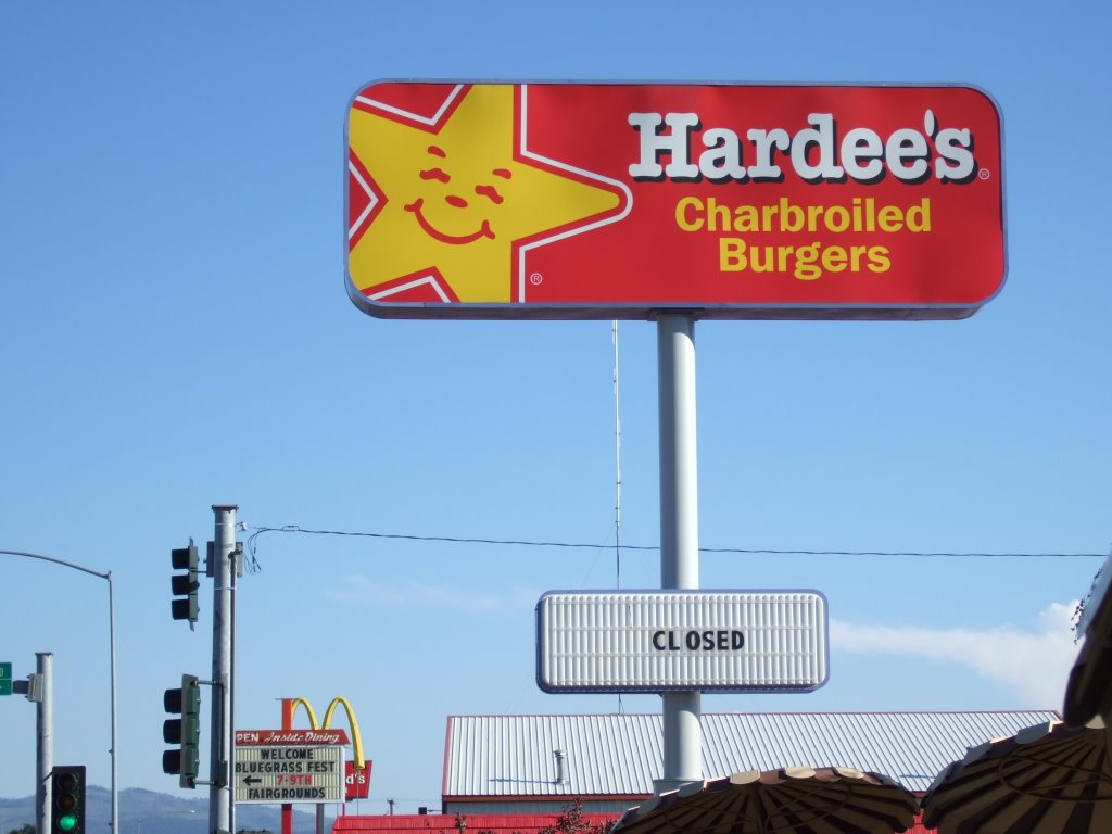
when i was little, i collected a bunch of shirt-tails stuffed animals from hardee's kid's meals.
they had ham and cheese sandwiches then - they were, in my memory, sort of an arby's competitor, rather than a renamed carl's jr.
Post a Comment