Today, much like any other day, I woke up. Not with a start, and not with any sort of grogginess, I just... woke up. And then I heard the chatter. What does one do when faced with unknown chatter in close proximity to the vehicle that they’re sleeping in, that also happens to be extremely difficult to get out of? Why, climb halfway out, peer into the passenger side mirror, and see a raccoon’s masked face peering right back at me. What’s more, however, is the fact that I believe this would-be woodland bandit to have climbed onto my truck. He was sitting on my back bumper, peering around the corner at me in the mirror. I struggled a bit to get out of the back and get a picture or something, but he potentially robbing rodent rapscallion... ran (away).
After that, I took my shower, disposed of disposables, and hit the road once again. I found my way back to Lebanon, MO, easily enough, but finding the Route wasn’t quite so uncomplicated. I stopped for gas and ice, and then the search was on.
I drove up and down the streets looking for some clue, studied my book and map, also for some clue, but the book at that point was assuming that the reader stayed on the Old Road for some time and just needed to take ‘a left’ or something. I need road names! Or Historic signs! Something more than ‘left,’ or ‘west!’
I decided to try and backtrack, but was rather unsuccessful. I hadn’t been paying attention upon entering Lebanon, and found that I couldn’t backtrack. So I decided to backtrack anyway. I found an old road, and started driving it back the general direction from which I’d come. After about fifteen minutes, I was about ready to give up. Then I saw a railroad bridge that the road I was on would cross under. Moments before I had seen that bridge, I had decided to turn around, and was merely looking for a good place to do so. Then I decided I would just go ahead and see what was on the other side of that bridge. On the other side of that bridge, was a T intersection with a Route 66 sign pointing both ways. I had found it once again.
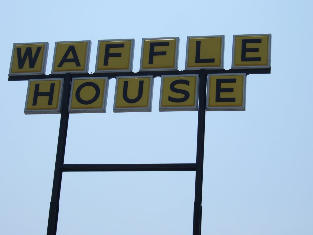
After that, I was able to stay successfully on America’s Main Street for quite some time (even without the signage to prove it). I was on my way into Springfield, MO, when I decided I was hungry, and that I would check out some of the local fare. I stopped at a (The?) Waffle House.

It was a thoroughly enjoyable experience. I sat at the bar, and listened as the big-rig regulars and the cook/wait staff bantered, and caught up. One of the things I’d been looking for, whether I knew it or not, was local flavor, and I’d found here, in Springfield’s Waffle House.
The people talked about television in their calming accents. It started with one of them talking about how the cable company had recently switched to the telephonic labyrinth style of customer service, and that because of this, he was probably going to switch providers. From there, people advised him rather severely to avoid going to satellite dish, and from there the folks just started talking about what shows they liked.
Among the favorites were shows about city folk having to live as the pioneers did (apparently there was a show about a rich family that hadn’t ever really had to work, who was chosen to go and live in rather primitive conditions—the highlight of the story was that the teenage boy’s first action upon getting home, was to lock himself in his bedroom and play videogames for some time uninterrupted, the restaurant people concurred: ‘that boy didn’t learn his lesson a’tall.’). One of the staff members spoke of how any one of them could make a go of it, but a woman stepped in and said, ‘my kids could do it, but I couldn’t!’ To which there was an honest chuckle. It was awesome.
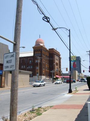
After that money well spent, I headed into Springfield proper, and stopped at the Shrine Mosque. The book said it was worth a stop and a picture, so I did just that:
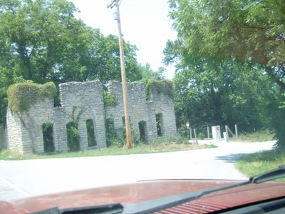
Just after I got outside of Springfield, I started to see the occasional dilapidated building. One in particular, however, caught my eye and seemed something more of a ruin. See for yourself:
It really wasn’t too long after that, that I found myself on the 12 mile stretch of Route 66 that runs through Kansas. The Kansas section of the Route was rather well marked, by comparison. I’ve been trying to get a picture of the Historic 66 signs from each state, so far so good.

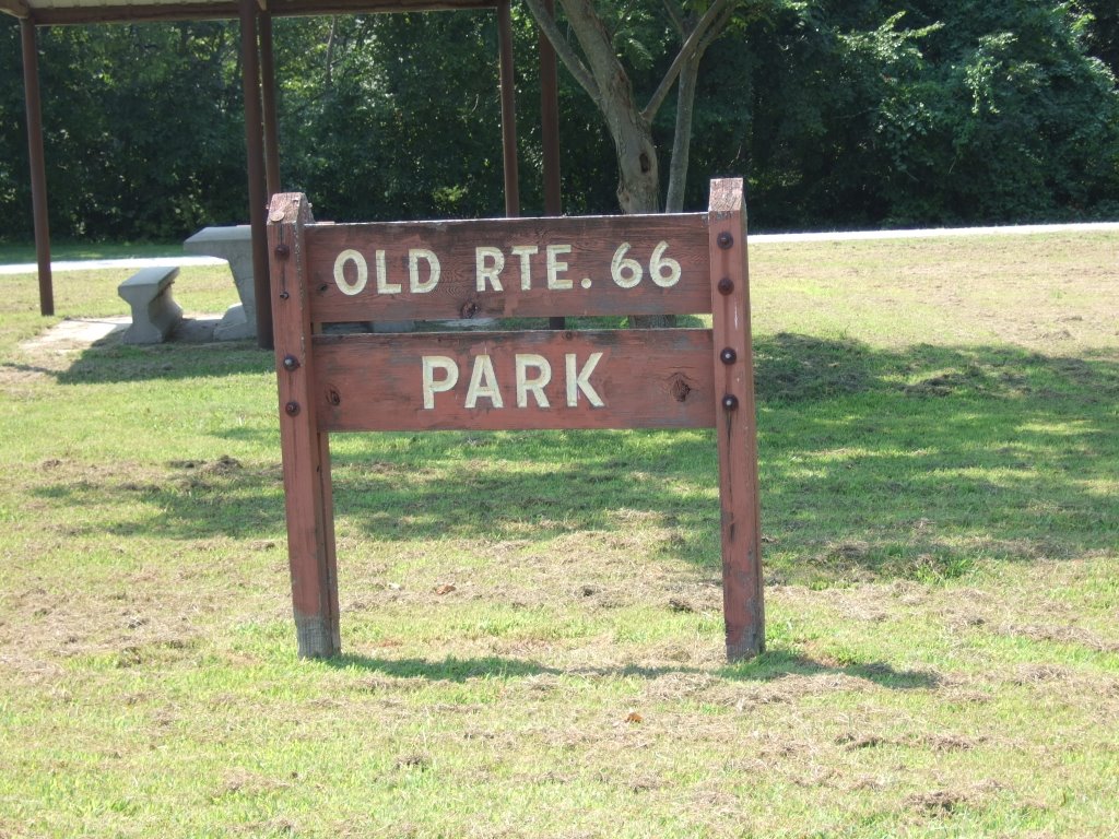
They also had a Route 66 park in Kansas. I think that because the road has so few miles in Kansas, that the state wants to celebrate it with more enthusiasm.

After Kansas, I entered Oklahoma from the north. The transition was not major. The transition from Missouri to Kansas, however, was. From mountains older than the hills, to plains that are flat like... something... well, really flat.
Eastern Oklahoma’s Interstate system is mostly a toll-based turnpike setup, so the Route 66 has been kept pretty well intact, with name changes (some very minor).
As I was passing through a small town on one of these well-preserved stretches of road, I happened to see this pre-historic (slight exaggeration) limousine. I thought it was neat, but in it I sort of saw the bloodlines of today’s stretched hummers and excursions... after that I sort of had mixed feelings about it.

Shortly thereafter, I found a section of the old Old Road, the original pavement for the most part ground to gravel, with little patches showing through, here and there. It looked as though it had been only one lane, but with wide shoulders for passing when necessary. It was a whole lot of fun to drive, though.

I got back on the new Old Road and found my way.
There were plenty of political signs posted, and this one was probably my favorite:

It doesn’t really say anything special, but I hope that you are able to read it. If not, it says quite simply, “Elect Payne.” I thought it would have been much better if it had said, “Choose Payne,” but I’ll take what I can get.
Shortly after this event, I decided it was time to stop and get myself something to drink. I pulled over to the side of the road, turned off the truck, took the key out, and went round back to open the canopy. Alas, and alack, the canopy, she wouldn’t open!
What to do, what to do?
Well, I couldn’t exactly drive around not being able to get anything out the back of my truck, so I stopped at a Wal-Mart parking lot in Miami (Miam-uh), OK. I climbed in through my back window, and took my canopy latching assembly all apart. It would seem a sort of ‘pinch-ring’ had come off, and let the rod assembly come in contact with the part that goes down in front of the tailgate. Simply put, the whole thing was jammed. I opened up the hatch, climbed out, got something to drink (which I desperately needed—as it turned out, it was about a hundred and five degrees just then). I climbed back in, got the tools as necessary, and spent about forty-five minutes fixing the thing. It was hot and slimy work. But, after getting it open, I knew that I had to be able to close it, and keep it closed.
After I left the parking lot, I was headed toward Tulsa, OK, and found some of the book’s directions hard to follow. I’ve been trying to drive as much of the Old Route 66 as possible, but sometimes the directions in the book (while virtually always hard to follow) don’t say whether it’s recommending a tourist attraction that’s on the old route, or the author is simply stating that, ‘since you’re in the neighborhood, you might as well see this.’ Anyway, when I am able to follow the directions, it can sometimes (and ironically) get me off track. It’s frustrating. The whole point of this paragraph it that the book had said to take a road (which I’m not sure I took), and that a little ways down that road, I would see two ‘non-identical’ bridges. Well, I went down what I thought was ‘the’ road, and indeed saw two bridges, but they didn’t strike me as particularly ‘non-identical.’ At least not enough to call them ‘non-identical.’ But here they are, so you can go to see:

Shortly thereafter, I arrived in the outskirts of Tulsa, and bought gas from another travelers-check-not-accepting-man-behind-presumably-bullet-proof-glass. Oh well. I drove on into town on the Old Route 66, and the road I needed to turn on, and went to my brother-in-law’s father’s house.
I went in, and we talked at length, about any number of topics, he showed me a lot of his artwork, and then we went out to dinner. Apparently there was a place in town called ‘Goldie’s’ that, whenever he has visitors, is a necessary stop. We got there at 5 after 8 p.m., and were greeted by seated employees who politely told us they had closed at 8. We drove around and found the Village Inn. That was pretty good.
I don’t remember if it was before or after dinner that I saw the “Golden Driller,” but it was an interesting sight. I had left my camera at his house, so I unfortunately don’t have a picture of it, but it’s this giant statue of a man drilling for oil. What’s interesting about it, however, is how un-manlike it looks. It’s apparent that it was not designed and built by artists, but by engineers. For instance, the statue’s legs are far too long. Like I said, it was interesting.
After that, we went back to his house, talked for a while longer, then he went to bed. I stayed up and watched television for a while, and then I too, went to bed. I slept on a couch that’s a hide-a-bed that couldn’t be un-hided because he’s working on a gigantic model house in the spare room. The couch was fine with me. I fell asleep.
 It was a thoroughly enjoyable experience. I sat at the bar, and listened as the big-rig regulars and the cook/wait staff bantered, and caught up. One of the things I’d been looking for, whether I knew it or not, was local flavor, and I’d found here, in Springfield’s Waffle House.
The people talked about television in their calming accents. It started with one of them talking about how the cable company had recently switched to the telephonic labyrinth style of customer service, and that because of this, he was probably going to switch providers. From there, people advised him rather severely to avoid going to satellite dish, and from there the folks just started talking about what shows they liked.
Among the favorites were shows about city folk having to live as the pioneers did (apparently there was a show about a rich family that hadn’t ever really had to work, who was chosen to go and live in rather primitive conditions—the highlight of the story was that the teenage boy’s first action upon getting home, was to lock himself in his bedroom and play videogames for some time uninterrupted, the restaurant people concurred: ‘that boy didn’t learn his lesson a’tall.’). One of the staff members spoke of how any one of them could make a go of it, but a woman stepped in and said, ‘my kids could do it, but I couldn’t!’ To which there was an honest chuckle. It was awesome.
After that money well spent, I headed into Springfield proper, and stopped at the Shrine Mosque. The book said it was worth a stop and a picture, so I did just that:
It was a thoroughly enjoyable experience. I sat at the bar, and listened as the big-rig regulars and the cook/wait staff bantered, and caught up. One of the things I’d been looking for, whether I knew it or not, was local flavor, and I’d found here, in Springfield’s Waffle House.
The people talked about television in their calming accents. It started with one of them talking about how the cable company had recently switched to the telephonic labyrinth style of customer service, and that because of this, he was probably going to switch providers. From there, people advised him rather severely to avoid going to satellite dish, and from there the folks just started talking about what shows they liked.
Among the favorites were shows about city folk having to live as the pioneers did (apparently there was a show about a rich family that hadn’t ever really had to work, who was chosen to go and live in rather primitive conditions—the highlight of the story was that the teenage boy’s first action upon getting home, was to lock himself in his bedroom and play videogames for some time uninterrupted, the restaurant people concurred: ‘that boy didn’t learn his lesson a’tall.’). One of the staff members spoke of how any one of them could make a go of it, but a woman stepped in and said, ‘my kids could do it, but I couldn’t!’ To which there was an honest chuckle. It was awesome.
After that money well spent, I headed into Springfield proper, and stopped at the Shrine Mosque. The book said it was worth a stop and a picture, so I did just that:
 Just after I got outside of Springfield, I started to see the occasional dilapidated building. One in particular, however, caught my eye and seemed something more of a ruin. See for yourself:
 It really wasn’t too long after that, that I found myself on the 12 mile stretch of Route 66 that runs through Kansas. The Kansas section of the Route was rather well marked, by comparison. I’ve been trying to get a picture of the Historic 66 signs from each state, so far so good.
 They also had a Route 66 park in Kansas. I think that because the road has so few miles in Kansas, that the state wants to celebrate it with more enthusiasm.
 After Kansas, I entered Oklahoma from the north. The transition was not major. The transition from Missouri to Kansas, however, was. From mountains older than the hills, to plains that are flat like... something... well, really flat.
Eastern Oklahoma’s Interstate system is mostly a toll-based turnpike setup, so the Route 66 has been kept pretty well intact, with name changes (some very minor).
As I was passing through a small town on one of these well-preserved stretches of road, I happened to see this pre-historic (slight exaggeration) limousine. I thought it was neat, but in it I sort of saw the bloodlines of today’s stretched hummers and excursions... after that I sort of had mixed feelings about it.
After Kansas, I entered Oklahoma from the north. The transition was not major. The transition from Missouri to Kansas, however, was. From mountains older than the hills, to plains that are flat like... something... well, really flat.
Eastern Oklahoma’s Interstate system is mostly a toll-based turnpike setup, so the Route 66 has been kept pretty well intact, with name changes (some very minor).
As I was passing through a small town on one of these well-preserved stretches of road, I happened to see this pre-historic (slight exaggeration) limousine. I thought it was neat, but in it I sort of saw the bloodlines of today’s stretched hummers and excursions... after that I sort of had mixed feelings about it.
 Shortly thereafter, I found a section of the old Old Road, the original pavement for the most part ground to gravel, with little patches showing through, here and there. It looked as though it had been only one lane, but with wide shoulders for passing when necessary. It was a whole lot of fun to drive, though.
 I got back on the new Old Road and found my way.
There were plenty of political signs posted, and this one was probably my favorite:
I got back on the new Old Road and found my way.
There were plenty of political signs posted, and this one was probably my favorite:
 It doesn’t really say anything special, but I hope that you are able to read it. If not, it says quite simply, “Elect Payne.” I thought it would have been much better if it had said, “Choose Payne,” but I’ll take what I can get.
Shortly after this event, I decided it was time to stop and get myself something to drink. I pulled over to the side of the road, turned off the truck, took the key out, and went round back to open the canopy. Alas, and alack, the canopy, she wouldn’t open!
What to do, what to do?
Well, I couldn’t exactly drive around not being able to get anything out the back of my truck, so I stopped at a Wal-Mart parking lot in Miami (Miam-uh), OK. I climbed in through my back window, and took my canopy latching assembly all apart. It would seem a sort of ‘pinch-ring’ had come off, and let the rod assembly come in contact with the part that goes down in front of the tailgate. Simply put, the whole thing was jammed. I opened up the hatch, climbed out, got something to drink (which I desperately needed—as it turned out, it was about a hundred and five degrees just then). I climbed back in, got the tools as necessary, and spent about forty-five minutes fixing the thing. It was hot and slimy work. But, after getting it open, I knew that I had to be able to close it, and keep it closed.
After I left the parking lot, I was headed toward Tulsa, OK, and found some of the book’s directions hard to follow. I’ve been trying to drive as much of the Old Route 66 as possible, but sometimes the directions in the book (while virtually always hard to follow) don’t say whether it’s recommending a tourist attraction that’s on the old route, or the author is simply stating that, ‘since you’re in the neighborhood, you might as well see this.’ Anyway, when I am able to follow the directions, it can sometimes (and ironically) get me off track. It’s frustrating. The whole point of this paragraph it that the book had said to take a road (which I’m not sure I took), and that a little ways down that road, I would see two ‘non-identical’ bridges. Well, I went down what I thought was ‘the’ road, and indeed saw two bridges, but they didn’t strike me as particularly ‘non-identical.’ At least not enough to call them ‘non-identical.’ But here they are, so you can go to see:
It doesn’t really say anything special, but I hope that you are able to read it. If not, it says quite simply, “Elect Payne.” I thought it would have been much better if it had said, “Choose Payne,” but I’ll take what I can get.
Shortly after this event, I decided it was time to stop and get myself something to drink. I pulled over to the side of the road, turned off the truck, took the key out, and went round back to open the canopy. Alas, and alack, the canopy, she wouldn’t open!
What to do, what to do?
Well, I couldn’t exactly drive around not being able to get anything out the back of my truck, so I stopped at a Wal-Mart parking lot in Miami (Miam-uh), OK. I climbed in through my back window, and took my canopy latching assembly all apart. It would seem a sort of ‘pinch-ring’ had come off, and let the rod assembly come in contact with the part that goes down in front of the tailgate. Simply put, the whole thing was jammed. I opened up the hatch, climbed out, got something to drink (which I desperately needed—as it turned out, it was about a hundred and five degrees just then). I climbed back in, got the tools as necessary, and spent about forty-five minutes fixing the thing. It was hot and slimy work. But, after getting it open, I knew that I had to be able to close it, and keep it closed.
After I left the parking lot, I was headed toward Tulsa, OK, and found some of the book’s directions hard to follow. I’ve been trying to drive as much of the Old Route 66 as possible, but sometimes the directions in the book (while virtually always hard to follow) don’t say whether it’s recommending a tourist attraction that’s on the old route, or the author is simply stating that, ‘since you’re in the neighborhood, you might as well see this.’ Anyway, when I am able to follow the directions, it can sometimes (and ironically) get me off track. It’s frustrating. The whole point of this paragraph it that the book had said to take a road (which I’m not sure I took), and that a little ways down that road, I would see two ‘non-identical’ bridges. Well, I went down what I thought was ‘the’ road, and indeed saw two bridges, but they didn’t strike me as particularly ‘non-identical.’ At least not enough to call them ‘non-identical.’ But here they are, so you can go to see:
 Shortly thereafter, I arrived in the outskirts of Tulsa, and bought gas from another travelers-check-not-accepting-man-behind-presumably-bullet-proof-glass. Oh well. I drove on into town on the Old Route 66, and the road I needed to turn on, and went to my brother-in-law’s father’s house.
I went in, and we talked at length, about any number of topics, he showed me a lot of his artwork, and then we went out to dinner. Apparently there was a place in town called ‘Goldie’s’ that, whenever he has visitors, is a necessary stop. We got there at 5 after 8 p.m., and were greeted by seated employees who politely told us they had closed at 8. We drove around and found the Village Inn. That was pretty good.
I don’t remember if it was before or after dinner that I saw the “Golden Driller,” but it was an interesting sight. I had left my camera at his house, so I unfortunately don’t have a picture of it, but it’s this giant statue of a man drilling for oil. What’s interesting about it, however, is how un-manlike it looks. It’s apparent that it was not designed and built by artists, but by engineers. For instance, the statue’s legs are far too long. Like I said, it was interesting.
After that, we went back to his house, talked for a while longer, then he went to bed. I stayed up and watched television for a while, and then I too, went to bed. I slept on a couch that’s a hide-a-bed that couldn’t be un-hided because he’s working on a gigantic model house in the spare room. The couch was fine with me. I fell asleep.
Shortly thereafter, I arrived in the outskirts of Tulsa, and bought gas from another travelers-check-not-accepting-man-behind-presumably-bullet-proof-glass. Oh well. I drove on into town on the Old Route 66, and the road I needed to turn on, and went to my brother-in-law’s father’s house.
I went in, and we talked at length, about any number of topics, he showed me a lot of his artwork, and then we went out to dinner. Apparently there was a place in town called ‘Goldie’s’ that, whenever he has visitors, is a necessary stop. We got there at 5 after 8 p.m., and were greeted by seated employees who politely told us they had closed at 8. We drove around and found the Village Inn. That was pretty good.
I don’t remember if it was before or after dinner that I saw the “Golden Driller,” but it was an interesting sight. I had left my camera at his house, so I unfortunately don’t have a picture of it, but it’s this giant statue of a man drilling for oil. What’s interesting about it, however, is how un-manlike it looks. It’s apparent that it was not designed and built by artists, but by engineers. For instance, the statue’s legs are far too long. Like I said, it was interesting.
After that, we went back to his house, talked for a while longer, then he went to bed. I stayed up and watched television for a while, and then I too, went to bed. I slept on a couch that’s a hide-a-bed that couldn’t be un-hided because he’s working on a gigantic model house in the spare room. The couch was fine with me. I fell asleep.
1 comment:
If the old limolike car is an original, and not something put together recently, then it was probably used as a small bus. I think the modern-day equivalent would be one of those extended vans with all the seats.
Post a Comment